Introduction
Geography studies the interactions between humans and the natural environment from the regional and spatial perspectives. Humans and nature are firmly connected to one another. Geography is the key to understanding our planet and its regions.
Geography is the study of phenomena related to nature and human activity. Geography often studies specific, delimited regions. Geography is thus divided into systematic and regional geography. Systematic geography[term: systematic geography – A field of geography that focuses on phenomena of natural and human geography.] is further divided into physical geography and human geography.
Human geography[term: human geography – A field of geography that studies human activity and its effects on Earth and its regions.] studies how human activities and society form and evolve regionally and spatially. The subjects covered by human geography can vary greatly. They can relate to the everyday living and working environments of people, or to the impact of the global economy and politics on regional development. Human geography provides solutions for the use and development of the environment and various regions.
Human geography from the regional perspective
In human geography, the focus is on the regional aspects of human activity and where the interaction between humans and nature actually happens. Human geography divides the world into various economic, political, and cultural constituents.
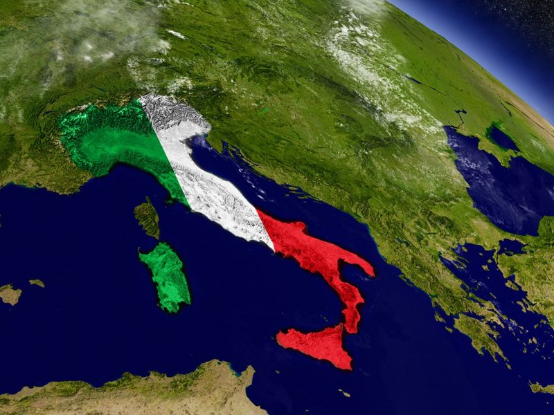
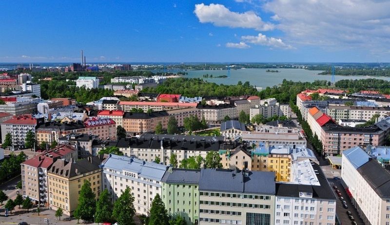
A region is an area that is internally coherent and delimited from other, surrounding regions. The world can be divided into continents and countries. These, in turn, can be further divided into provinces, municipalities, and neighbourhoods. Regions can also be shaped by their cultural circles, economic interactions or ideas that people have about them.
Through the spatial analysis of human geography, we understand the kinds of regional units the Earth is made of and the smaller places it is made up of. This gives us a better idea of the development, resources and needs of different regions. Thus, we can identify where development is progressing well, and which regions are facing the greatest challenges.
Human geographic from the spatial perspective
The regional perspective of human geography considers the location of human activity and where human interactions with nature take place. From the regional perspective of human geography, the world is divided into economic, political and cultural regions. The regional perspective is deepened by the spatial perspective.
The spatial perspective of human geography studies why the world is divided into regions and places. It also examines what kinds of purposes various local and global phenomena have. The spatial perspective also considers the kinds of purposes that relationships and locations serve for the interactions between humans and nature, and how the planet is divided into various regions based on these purposes and interactions.
Spatial research attempts to explain how location affects the interaction and development between regions and places. We get to find out how and why different regions, such as countries or cities, change. As a result, we can understand the basics behind why the world is divided into constantly changing and different economic, political, and cultural regions. We can also identify the reasons and causes of the challenges and opportunities within and between regions.
The worldview created by the regional and spatial perspectives
It is good to know where, how, and why various phenomena occur, whether we are thinking about our hometown or about global matters.
Gaining deeper knowledge about a region's features may help us to understand various phenomena. By understanding the region itself, we can utilise the resources provided by the region in a more sustainable way.
With the help of human geography, we can solve regional issues that range from global phenomena to the everyday struggles of individuals. Examples of such issues include population growth and urbanisation, climate change, social inequality, and the depletion of natural resources. The potential of a region lies in the skills of its inhabitants, the economically efficient and sustainable use of its natural resources, and the way its government guides its development.
The regional and spatial perspectives of human geography enable us to see the potential in economic and political cooperation between and within regions. Cooperation leads to new ideas, functions, and innovations, all of which help to develop regions further. On the other hand, the disruption of economic and political cooperation might lead to conflicts within or between sovereign countries.

Geographic research
We need many kinds of sources and research methods to explore our own immediate environment and the world at large. A significant amount of information about the Earth, its countries and its different regions is available through online databases. Some of the information is available in the form of direct geospatial data that describes and exemplifies the phenomenon in a specific region. More information can be acquired through personal surveys, interviews, and observations.
Research means that systematic scientific action has been taken in order to figure out an issue. Usually, research consists of reading previous studies and their results, defining the subject, formulating research questions, defining the central concepts, choosing the research method, collecting the research material, analysing the materials, and answering the research questions using logical deduction. Finally, the findings of the study are presented.
Collecting research material that provides the most valuable information is essential. However, it is equally important to apply research methods that draw out the relevant information from the research material. It is also vital to include a clear and comprehensive presentation of the research results. In human geography, a variety of quantitative and qualitative methods, as well as up-to-date geospatial information, are used to obtain and analyse information.
Quantitative methods that help to obtain and analyse the research material include measurements, surveys and various interviewing methods. These methods showcase how common and widespread the studied phenomenon is, and what kind of significance it has to different regions.
Qualitative methods that help to obtain and analyse the research material include observations and interviews. These methods demonstrate why a certain phenomenon is occurring, and why there are differences between the regions.
Geospatial information provides detailed descriptions of where the exact location of a phenomenon is and what functions it has. Geospatial information can also be used to explain the interactions and relationships between different phenomena in the same region.
Fields and questions of human geography
Field | Research questions |
Economic geography | How does giving up the use of coal affect the competitiveness of different countries? |
Urban geography | How does the quick rise of new cities affect the industries and the living conditions in China and Africa? |
Political geography | How has the United Kingdom’s exit from the EU affected international trade? |
Population geography | How does migration affect the development within and between different countries? |
Development geography | How does climate change affect Africa? |
Cultural geography | How do the original cultures of various regions persist in the age of the internet? |
Health geography | How did the COVID-19 pandemic spread regionally within a specific country? |
Quantitative research methods
In quantitative research[term: quantitative research – Refers to research, where precise and statistical methods are used. The research material is based on quantitative measurements.], a geographer collects new material for research based on observations and measurements, or by relying on existing materials such as statistics or databases. In examining this new material, the geographer tries to understand the phenomenon at hand and create larger generalisations that might go beyond the research material. This kind of research makes use of precise computational statistical methods and models.
Quantitative research methods are great for geographic studies that focus on larger sets of observations, such as those concerning regional changes in climate, the environment or populations. Quantitative research materials are gathered and analysed through measurements, surveys and interviews. These methods provide information about how common and widespread the studied phenomenon is, and how much it affects different regions.
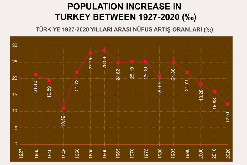
Statistics about a region’s population and their activities make the precise and systematic study of the region possible. All kinds of statistics can easily be found on the internet, in statistical books or in various databases.
The direction of development can be seen from examining the statistics of several years in a series. The observations made about different regions can be compared. Statistical methods can be used to highlight significant connections between observations. Afterwards, the reasons and causes behind the observed phenomena can be reflected upon.
Information about the development of regions is gained by looking at population numbers, the number of people in different age groups, and the changes in these numbers over time. In less developed regions, children make up a large share of the total population, while the number of elderly people is low. Statistics on education and health in the region indicate the level of well-being. The more highly educated people there are, the more developed the region. A high number of illiterate people is a sign of problems in the region's development. Common diseases are also quite good indicators of a region’s level of development.
Statistics that concern industry and livelihoods are useful when examining a region's economy. The most common indicator of economic development is the value of all of the goods and services produced in the region over a year. This is called the gross domestic product (GDP). In order to compare different countries and regions, GDP can be divided by the population (GDP per capita). High unemployment rates indicate economic issues in a region. If a great share of the workforce is employed in agriculture, it shows that the region is either less developed or specialised in agriculture. Sometimes, the amount of natural resources is evident in the statistics. The number of mining operations is one indicator of the utilisation of a region's natural resources. In industrial countries, the share of people employed in industry is higher than in other countries. In all highly developed countries, the vast majority of people work in services.
Quantitative research hypotheses in the form of research questions
Qualitative research methods
In qualitative research[term: qualitative research – Research where the focus is on finding the meaning or purpose behind the phenomenon in question. Often based on observations and interviews.], a geographer collects new material for research based on observations or existing materials. Qualitative research is based on gathering research material through discretionary sampling which the geographer then examines, trying to find the meaning or purpose of the phenomenon in question. Generalisations of any kind are hard to extend beyond the studied materials or sets of observations.
The goal of qualitative research is to proceed from the research materials towards more profound conclusions that are supported by a theory, i.e. a framework that could explain the observations. Qualitative research methods are great for geographical studies about isolated cases or smaller data sets. These include studying the meaning of a phenomenon or an event in a municipality, studying the meaning of one’s own surroundings, or studying the meaning of a nearby place.
Qualitative research hypotheses in the form of research questions
|
Field |
Research questions |
|
Economic geography |
Are there differences in willingness to apply for a mortgage in different parts of the country? |
|
Urban geography |
Do young people prefer to move to the biggest cities in the country because of the services available? |
|
Political geography |
Does the political background at home affect the different political stances of young people in different regions? |
|
Population geography |
Do the economic issues explain the low birth rates in a country? |
|
Development geography |
Are there differences between Kenyan and Nepalese high school student’s dreams of developing their home country? |
Cultural geography | Are there differences in the worldviews of people that have different cultures? |
Health geography | Are high school students living in big cities more likely to be concerned about their health than those living in the countryside? |
Qualitative research methods include interpretation, observation and interviews. These have always been important ways of investigating the features of different regions. They cannot be used to make precise measurements, but they can provide an overview of the region and phenomenon in question.
Qualitative interview methods can take the form of individual or group interviews. The interview can be based on a precise plan, such as a questionnaire with limited questions and themes. Interviews can reveal different perspectives and arguments about the good and bad aspects of the region under study.
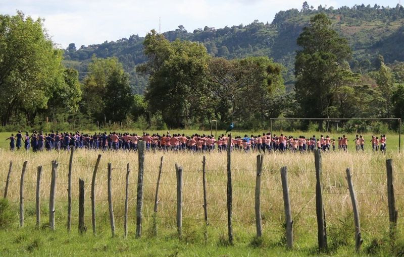
Careful and attentive observation can be used to quickly and efficiently study how a city or region has developed. The observer pays attention to things such as the condition of the roads and buildings, the amount of traffic, how much litter there is on the streets, the efficiency of public transport, the types of clothing that people wear, the interactions between people, the ethnicities of the workers, the availability and price of consumer goods, or perhaps the English language skills of people passing on the street. While moving through a city, a region or a country, it is normal to observe the differences between regions. Conversations with ordinary people and interviews with experts give new perspectives on the subject under study.
Experienced observers can quickly get a feel for the area and its level of development. It is essential to record observations and interviews accurately. It is also useful to follow local and national media outlets and compare their information with information from other sources.
Geospatial methods
Geospatial methods are common tools in human geography. They are especially helpful when presenting information about a region. They also help to demonstrate the location of a studied phenomenon, as well as its features and regional presence.
Geospatial information can take various forms. It can be information that is experienced by the individual, information measured by others, or information collected by the society. Geospatial information always includes the geographical location of the information in question. Examples of geospatial information include the volume of traffic at a particular intersection or the current location of an object during a postal delivery.
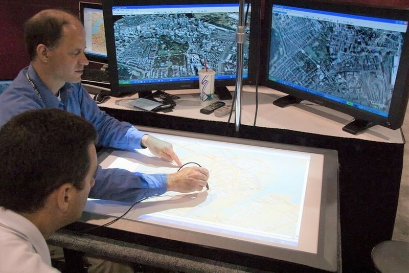
For many countries and regions, accurate geographic information is readily available. It provides detailed information on the population, economy and the environment. Often, this information is available down to the level of a square kilometre. This information is useful in many geographical contexts. For example, the land use of a region can be studied by interpreting maps or satellite images, while positioning systems (e.g. GPS) are used to study changes in the location of people and things. Today, location data is connected to many products and objects. Location information is often presented in digital form. Spatial digital information is part of geomedia, a diverse set of information and media linked to locations and places.
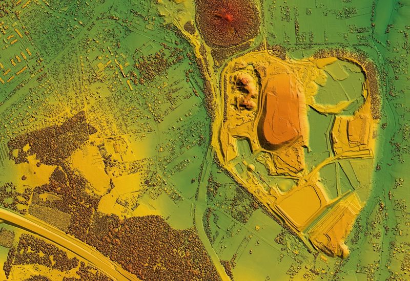
Observations about changes in land use can be made from comparing older and newer maps to each other. In order to use the spatial data, there must be a connection to the databases of the region. Geographers use geographic information systems (GIS) to process and organise geospatial data. Geospatial data is mostly processed using quantitative research methods, such as statistics, computational geometry, or network theory. Geospatial data is useful for planning and developing the environment and society.
Digital geospatial data can be complemented by adding information that was gathered by yourself or others. Citizen science is done by ordinary people who volunteer to gather, categorise, or analyse observations about various phenomena. This sort of qualitative data can be later connected to the quantitative data of various databases, leading to a better understanding of the studied phenomenon. Through participation and crowdsourcing, ordinary people can take part in geographical research. This can lead to a broader interest in various geographical subjects, such as the local environment, and bring about positive developments.
Presenting research results
In human geography, it is important to present information through visualisation. Pictures, charts and maps are used to accompany texts and tables. Nowadays, videos are also a common means of presenting information. When done correctly, visualisation can greatly aid the comprehension of the research subject. Interactive digital presentations are also great at illustrating research results.
The focus of pictures, charts and maps should be in the forwarding of the essential information. Irrelevant elements should be stripped away to make the visualisation as easy to interpret as possible. A great map is worth more than a thousand words. Maps should always include an indicator for scale.
Virtual reality and augmented reality can also be used to present research results. They are also useful for getting to know a region or a place. Virtual reality (VR) means experiencing a simulated world through VR glasses and other devices that use digital technology. Augmented reality (AR) means that our physical world has been complemented with digital 3D characters and elements.
Examples of gathering data and presenting results

Summary
- Geography studies the interaction between humans and the natural environment from regional and geospatial perspectives.
- Human geography studies where human activity is located, and where the interactions between humans and nature happen.
- Human geography also studies phenomena from a geospatial perspective, asking where and how interactions between humans and nature happen, and how and why various regions and places are connected to one another.
- Geographical information is gained through observations provided by quantitative, qualitative and geospatial research methods.
- Quantitative research methods, such as measurements and statistical studies, show how common and widespread the studied phenomenon is.
- Qualitative research methods, such as interpretation and observation, show what kinds of meanings people assign to the studied phenomenon.
- Geospatial methods provide and demonstrate information about the locations and the features of various phenomena, as well as interactions between different phenomena.
- Maps, diagrams and pictures are important methods for presenting the results of human geography.
- Virtual and augmented reality can be also used to visualise the phenomena of human geography.