Test your starting level! 🌐︎
In this unit, we will learn more about European geography.
You can check your stargin level by completing the tasks below.
Please note that you do not need to know all the right answers already.
If all your answers were correct, you already know quite a bit about European geography!
If you got 3-5 correct answers, your starting level is good. Hopefully you are motivated to learn more!
If you got 0–2 correct answers, your starting level is weak. Hopefully you are interested in learning more!
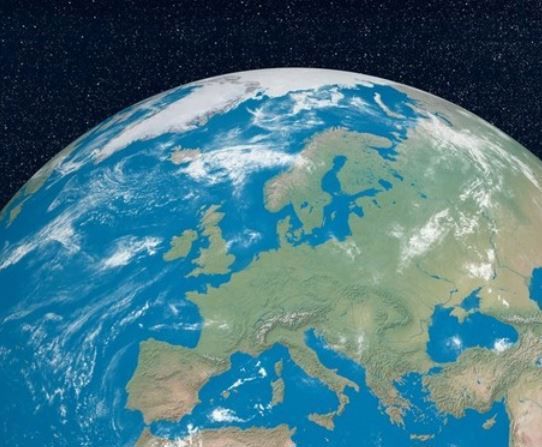
What is Europe?
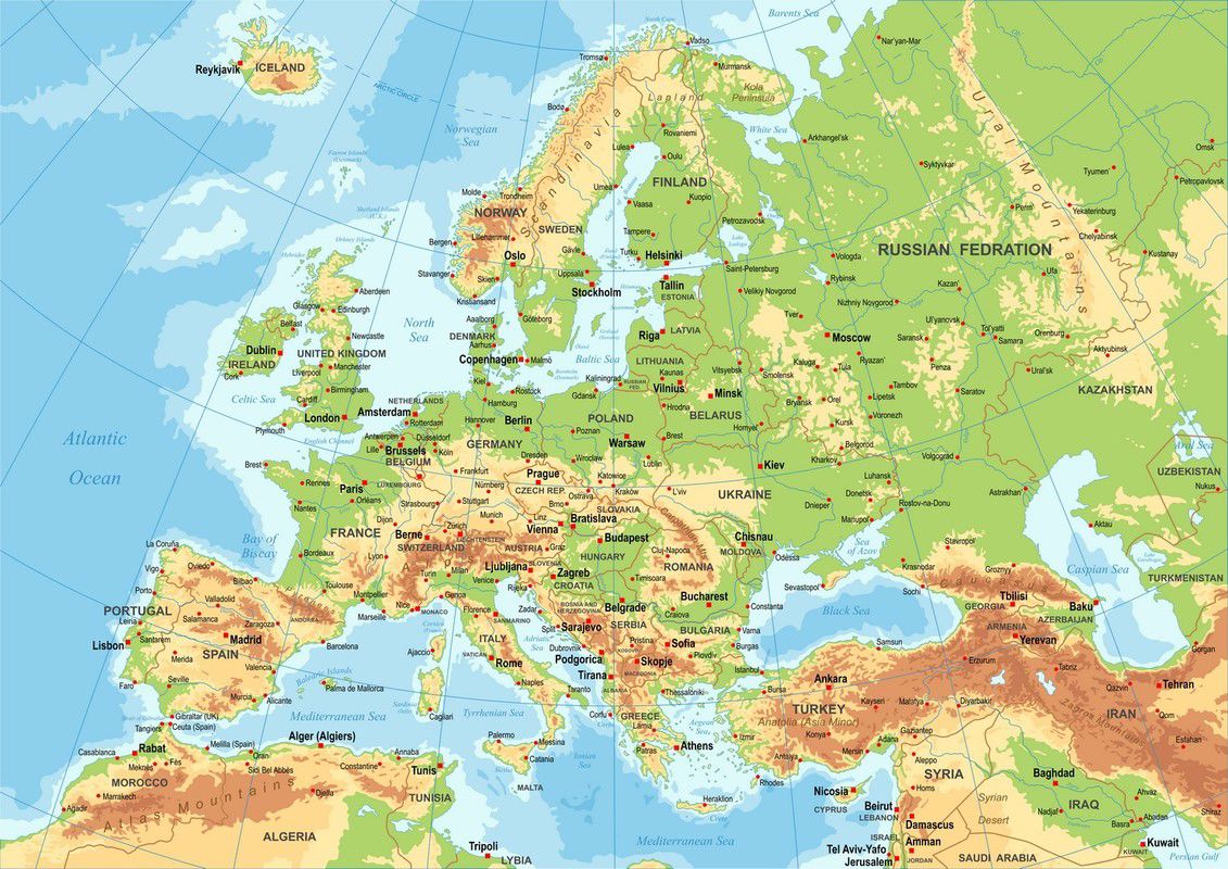
Europe is a continent. Its borders are the Atlantic Ocean, the Mediterranean Sea and the Arctic Ocean.
Coordinates
A straight line called the equator runs horizontally through the map of the world. The equator divides the planet into its northern and southern hemispheres. In the northern hemisphere, the day is at its longest in July. In the southern hemisphere, the day is at its longest in December.
The equator and other lines that run parallel to it are called latitudes. Latitudes can be used to describe where a certain place is located on the planet. For example, the latitude of Helsinki is 60 degrees North (60° N).
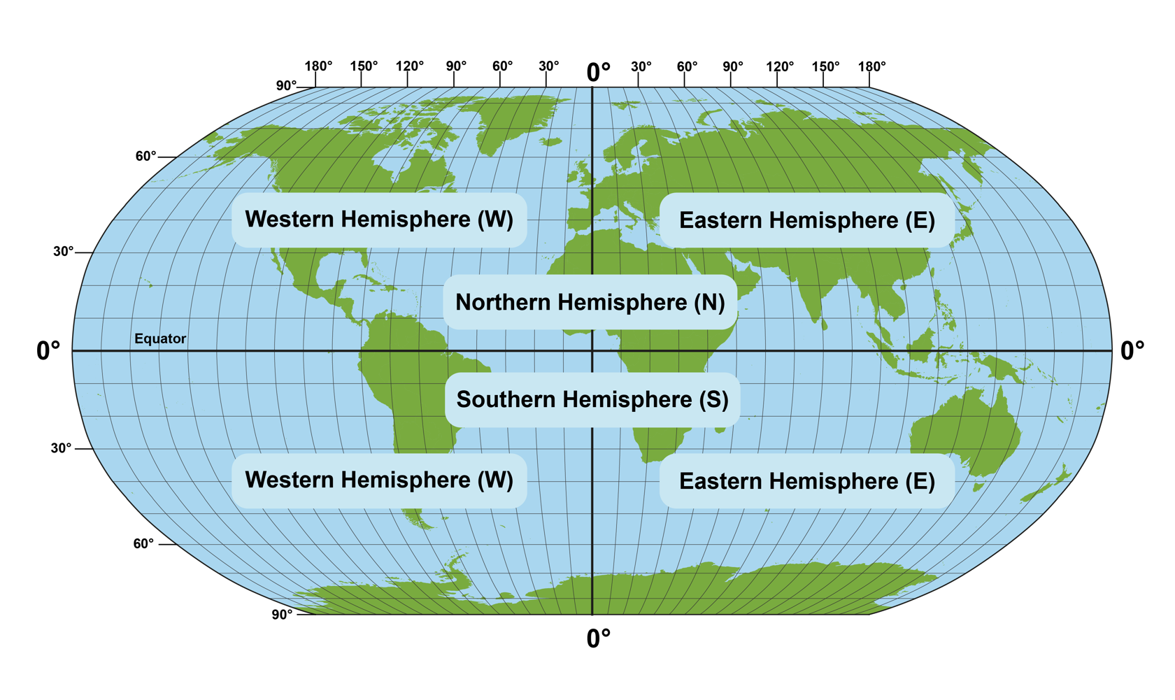
There are also vertical lines running through the world map. These lines are called longitudes. The line of zero longitude runs through London, the capital of Britain. It is known as the Greenwich meridian. On the opposite side of the planet is a longitude of 180 degrees. This is known as the Date Line.
Like the equator, the Greenwich meridian also divides the planet into two hemispheres. The eastern hemisphere is located to the east of the Greenwich meridian, whereas the western hemisphere is located to the west of it. Together, the lines of latitude and longitude cover the map of the world with a coordinate grid.
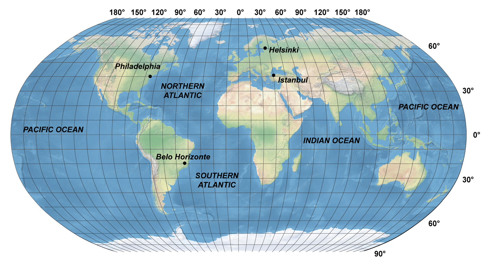
The coordinate grid can be used to describe where a certain place is located on the planet. For example, the latitude the Finnish capital city Helsinki is 60° N, and its longitude is 25° E. In contrast, the longitude of Belo Horizonte, Brazil, is 20° S and its longitude is 45° W.
Continents and oceans
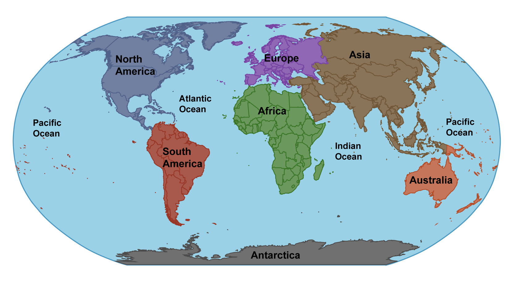
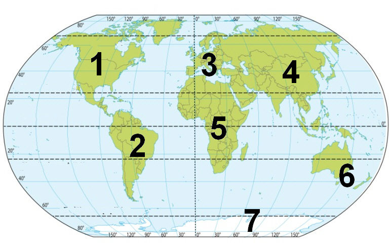
Europe is one of the planet's seven continents. The other continents are Asia, Africa, Australia, North America, South America and Antarctica. In geological terms, Europe is actually part of the Eurasian continent, together with Asia.
The borders between Europe and Asia are the Russian Ural and Caucasus Mountains, as well as the Black Sea. Europe is bordered to the west by the Atlantic Ocean. Europe is separated from Africa by the Mediterranean Sea.
The seven continents are surrounded by three oceans: the Atlantic Ocean, the Pacific Ocean and the Indian Ocean.

European nations
Europe can be displayed on a map. A national map displays the most important features of an independent nation, such as its most important cities. A topographic map focuses on displaying the geographic features of the region, such as its mountain ranges.
Although Europe is a relatively small continent, it contains many independent nations. During this course, your job is to learn the locations of all the largest and most important European nations.
Finding European nations on the map
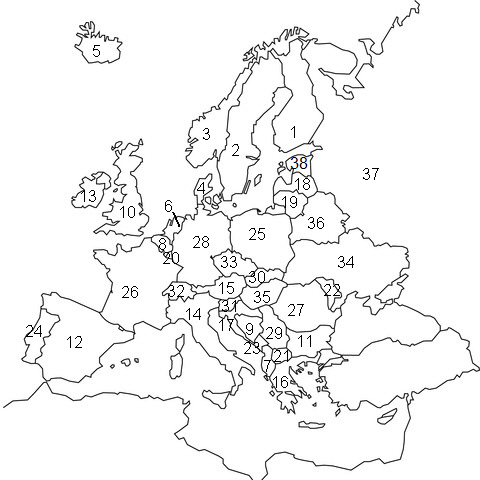
The map on the left shows the most important European nations in numbers. Using this map, it is easy for you to practice naming and finding different European nations!
The Nordic countries: 1. Finland, 2. Sweden, 3. Norway, 4. Denmark, 5. Iceland
Other European nations: 6. the Netherlands, 7. Albania, 8. Belgium, 9. Bosnia and Herzegovina, 10. the United Kingdom, 11. Bulgaria, 12. Spain, 13. Ireland, 14. Italy, 15. Austria, 16. Greece, 17. Croatia, 18. Latvia, 19. Lithuania, 20. Luxembourg, 21. Macedonia, 22. Moldova, 23. Montenegro, 24. Portugal, 25. Poland, 26. France, 27. Romania, 28. Germany, 29. Serbia, 30. Slovakia, 31. Slovenia, 32. Switzerland, 33. the Czech Republic, 34. Ukraine, 35. Hungary, 36. Belarus, 37. Russia, 38. Estonia.
The following small nations are not numbered on the map: Andorra, Liechtenstein, Malta, Monaco, San Marino and the Vatican.
Test your knowledge 🌐︎
1.
2.
3.
4.
5.
6. Australia and Oceania
7.

On the left:
In the middle:
On the right:
Terminology
The map of Europe
Term | Explanation |
continent | A large land region of the planet Earth. |
longitude | A line that runs vertically across the planet, between its South and North poles. |
latitude | A line that runs horizontally across the planet, parallel to the equator. |
Summary
- Earth has seven continents: Europe, Asia, Africa, Australia (and Oceania), Antarctica, South America and North America.
- Europe is a small continent that is bordered by the Atlantic Ocean, the Arctic Ocean, the Mediterranean Sea and the Ural and Caucasus Mountains.